AND FINALLY I have caught up to this week!
Monday the 17th marked the first day of Mountain Geology class. My professor, Ben, is French and sometimes a little hard to understand when he is using technical terms. We ask for spelling a lot.
It was an introduction to the class, the basics about types of rocks, how they are formed, and how to identify them. I don’t have a particularly strong interest in sharing the details about rocks with you, but I’m happy to address any questions if you have them.
Tuesday’s class was about the formation of the world, so that was more fun.
The most commonly accepted consensus about the formation of the universe:
The universe was formed during the shrinking of a nebula, maybe due to energy received from a supernova. Particles came together and took on a rotation motion that created a disc of matter; the materials gained gravity and released heat as light elements - especially hydrogen and helium - had nuclear fusion reactions and started growing a protosun. Denser elements formed planetesimals and eventually came to orbit the sun. Highly radioactive elements like Ca-41 and Al-26 quickly decayed and released extreme heat that melted elements and melted the materials that would become earth. Once melted, things shifted so denser particles settled in the core and lighter ones were suspended further away from the core.
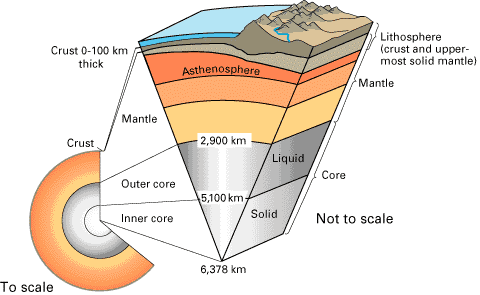
And then we learned about the layers of the earth and the 3 types of volcanism that create landmass. A simplified diagram follows that gives the gist of the layers:
Wednesday we discussed lithospheric aka tectonic plates and convergent and subduction zones. After class, I went with Anna to Old Town Quito, where we explored several churches and the City Museum. I will perhaps load those pictures a bit later. I went to dinner with some classmates and came back to my host house to find it empty -- it turns out my host dad had a small stroke that day and was transported to the hospital. It agitated his heart, as a result of a heart attack he'd had 11 years ago, but he came back on Saturday and is feeling very much better. He doesn't seem to have complications.
Thursday was about crustal deformation as a result of tectonic plate convergence and divergence, types of faults and folds, and earthquakes and volcanoes. This was my favorite day so far.
 |
| This shows the age of the seafloor at different parts of the world. The redder area by the Pacific coast of South America is along the East Pacific Ridge, which spreads very quickly. The Galapagos hotspot along with the East Pacific Ridge created the Nazca plate and the Cocos plate, which subduct under the South American plate and cause all the volcanoes and earthquakes in the region. |
Friday we left at 8 am for our trip to Quilotoa, during which we made plenty of stops to make observations and record data about the landscape surrounding the volcano.
 |
| The second or third stop we made was to examine this fold in the earth, conveniently cut through by road construction so that we could look at specific parts of it. |
 |
| This is Ben, my geology professor. There the feature of interest is the break in the rock striations as a result of activity along an inverse fault occurring after the effects of the compression causing the fold. After analyzing the three different types of rock in this fold, Ben was able to tell us that this piece of crust was actually a marine sequence of striations. We were very far inland! It is incredible what the forces of the earth's crust does to shape our landscapes. |
 |
Much of the land on the way to Quilotoa is covered with farm area. Lots of llamas/alpacas (I'm not certain of the difference when one of each is not next to each other for comparison) and sheep.
It is very hilly due to volcanic deposits and lots of tectonic plate activity under Ecuador. |
 |
| Before arriving to Quilotoa, we stopped to examine this portion nearby the Taochi river path through the volcanic deposits. Quilotoa's last eruption 800 years ago was very explosive - we know this because the minerals and composition of the rock in these layers showed the lava was very viscous and some had a high content of water. |
 |
| The striations are due to different pulses of lava erupting from Quilotoa, most of it is volcanic ash and pumice. We are heading into the caldera. |
 |
| Pretty flowers at the inner edge of the crater. We climbed into the caldera the first day to enjoy the view. Then we raced ourselves back up and that was a little difficult. |
 |
| Me at the end of the path that goes into the caldera, dorked out in baggy Carolina wear. |
 |
| A band playing pipes, drum, washboard-like side of thermos, and maybe guitar serenaded our Thursday night post-dinner conversation at the hostel. |
Saturday (yesterday! Look at me catching up!) we woke for breakfast at 7 and proceeded to hike the rim of the volcanic caldera - which is not a crater, but can be thought of as similar to a crater. The caldera was created when the bulge of earth that is the volcano was filled with a lava dome as a result of very viscous (thick, not liquidy) magma rising to the surface and then some other reactions that caused the Quilotoa volcano to erupt, deposit tons of pyroclastic material into the surrounding valleys, and cleared out the top of the volcano to leave a space for rainwater to collect for 800 years and for nerds and tourists alike to hike around and admire how pretty it is.
 |
| Ben pointed out the results of the previous eruptions of Quilotoa over this landscape. |
 |
| The smoothness is due to volcanic flow. |
 |
| This is how we started, nice and bunched togethersince the beginning of the trail is downhill and relatively smooth. And then the slopes became more dramatic and we were much further apart. |
We hiked about a fourth of the way around the caldera making frequent stops for observations about the landscape of the area, the resulting masses of mountain-like structures, volcanic deposits, and patterns of rocks that give us evidence of what happened as a geological history of the area. After all these observations, the rest of the hike was a pleasure hike, or maybe somewhat better described as a challenge hike because there is a deceptively high number of peaks to get over on the way around the caldera. The point that Ben identified as the summit is about a third of the way around the rim from our starting point, and it was a bit of a physical challenge for me to reach it.
 |
The lava dome part is in the distance. The little lighter-colored line over the edge of the caldera is the trail that we hiked. Uphills are more challenging than they appear.
 |
| This is a lava rock on the eastern edge of the caldera showing that particular part of the caldera was formed due to a lava dome. We know it is a lava rock since it is dacitic, meaning it has a certain concentration of ground mass (volcanic ash, aka the gray stuff that isn't crystal), quartz, biotite, plagioclase, and amphibol. |
Once there, we took some pictures, ate snacks, rearranged our belongings, and kept going. All except one of our classmates. When we reached the halfway point around the rim (after a lot of challenging slopes, ashy rock ledges, and steep dusty trail portions), we paused to recount everyone and realized someone had turned back around because they had gotten lost. So with a bit of huffing and puffing, we figured out that we had to turn back around to the summit again instead of hiking the second half of the rim. So we did that.
 |
| Anna, Laleña, and I at the summit pausing for a picture and some refreshments before continuing to hike. |
 |
| We are Student U! My summit picture in honor of this summer. |
|
I realized that I hike steep slopes a lot better when I encourage myself while at the same time coaching my own breathing. It’s something along the lines of exhaling slowly while saying “GOOD” for slightly challenging inclines and counting “GOOD, 2, 3, 4, GOOD, 2, 3, 4” for steps and breaths on very challenging inclines. By combining this with two or three stops to recollect with my classmates and casual conversation during flat parts of the trail, we made it back to the hostel for lunch by 2 pm as expected. However, I am proud to note that 2 pm was the time assuming we would go all the way around the rim and not double back the way we did. Since we passed the summit twice, we traveled a total distance greater than the trail all the way around.
 |
| It was at this point that I laughed at the curviness of the path and how cruel it was to have such a nice downhill to be followed by an uphill. But so it goes in all situations, right? I think we made it to the other side of the hill that is visible here before turning back. |
 |
| We headed back after reaching a spot several hills past the summit of the caldera because we realized one of our classmates had gone back to the hostel out of confusion after we stopped and started hiking again past the summit. This is us tired and waiting for some people to catch up as we headed back to the hostel. |
After lunch, we loaded back on the chauffeured van and came back to Cumbaya. There was a long pause in traffic at one point due to a landslide at a construction site next to the road, but other than that travels were just fine.
 |
| I just got an app on my phone that takes panoramas. This looks kind of funny, maybe because I don't quite know how to use it properly. It scrolls interactively on my phone screen so it looks like I'm standing and turning around in the landscape, but I can't get it to do that on a computer screen... |


Lack of Oxgen and interest may contribute to more randomness of this blog. But we still love it!
ReplyDelete